











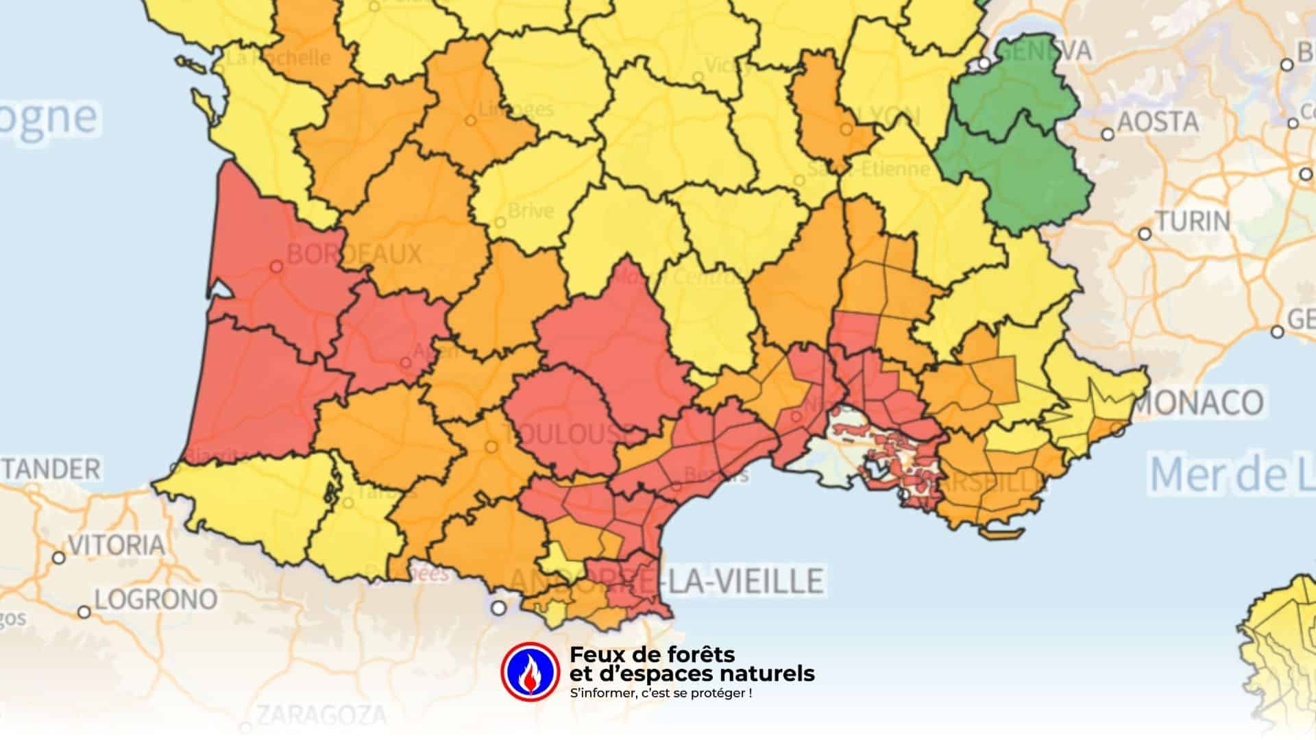
This Sunday, 17 August, the situation is critical on the wildfire front. According to the map Forest Fires.fr , eleven departments are on red alert, the highest danger level: the Gironde, the Landes, the Lot-et-Garonne, the Tarn, theAveyron, the Vaucluse, the Bouches-du-Rhône, theHérault, theAude and the Pyrénées-Orientales. In these areas, the risk is considered exceptional, with a high likelihood of uncontrollable fires breaking out.
> View today’s map
Beyond these eleven departments, the whole of southern France is on orange alert. This includes Occitanie, Provence-Alpes-Côte d’Azur and part of Nouvelle-Aquitaine, where drought, heat and wind are creating a high risk. The rest of the country remains on a yellow alert, with a moderate but real risk, particularly in parched forests.
These alert levels are used directly by the prefectures to restrict access to forested areas and by the emergency services to pre-position additional resources. During a red alert, access restrictions are widespread and aerial and ground surveillance is stepped up.
Extreme weather conditions
Temperatures exceeding 35 °C, combined with persistent drought and strong winds (the mistral, tramontane or vent d’autan), account for this extreme risk level. In the south-east, the Bouches-du-Rhône, Vaucluse, Hérault, Aude and Pyrénées-Orientales are under threat from the rapid spread of flames. In the south-west, the Gironde and the Landes – already scarred by the massive fires of 2022 – are on maximum alert.
The fire service and Civil Protection are on full alert. Land and air patrols are monitoring the mountain ranges so that they can respond as quickly as possible should a fire break out. The authorities fear large-scale fires if people do not remain vigilant.
Everyone’s responsibility
Nine out of ten fires are caused by humans. The authorities remind the public that simply throwing away a cigarette end, having an impromptu barbecue or carrying out work that produces sparks can be enough to start a fire. In areas on red alert, residents and holidaymakers are urged to exercise the utmost caution and to report any suspicious smoke by dialling 18 or 112.
Several departments have already issued prefectural decrees banning access to forests and severely restricting high-risk activities. Although these measures are restrictive during the summer months, they are essential to prevent the flames from spreading dramatically in the context of extreme drought and heat.
To keep up to date with current fires, our real-time fire tracking map allows you to view the onset of fires and how they develop. You can also view the fire risk map, updated daily, so that you can find out the risk level in your department.